0
items
$0
Colored Pencil

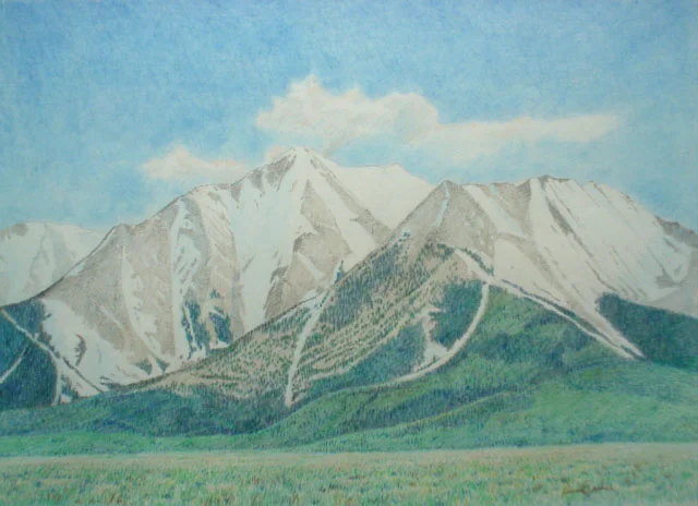
Capitol Peak
Drawing was made on the spot while sitting in the car out of the sun and wind. The view is in the range near Aspen, Colorado. Drawing size is 12 inch by 18 inch. Drawn with colored pencil and graphite pencil.
Price is $250.00 unframed.
It would have to be framed like a watercolor under glass.

Delaney Barn below the Highline Canal
This rather totally round wood barn sits on the eastern side of Aurora, CO, an eastern suburb of Denver. It is part of the Aurora City public parks system and was most likely built at its present location to be near the canal completed in the 1860s.
Drawn in colored pencil with graphite on 14 inch by 10.5 inch white paper.
Unframed. Must be placed under glass when framing.
Sale price $100

Grand Canyon from Battleship Mesa with Isis Temple in the distance
Drawn on the spot on one of our camping trips to the Canyon. The reddish orange feature in the lower part of the image is Battleship Mesa. It juts out from the south rim with the Colorado River flowing directly below its most northern edge. View is looking north to the north rim which has a much higher elevation than the rim on the south.
Drawn in colored pencil on white paper 16.5 inches by 14 inches.
Comes unframed but matted. When framed must be placed under glass.
Sale price is $300

Grand Canyon view of Osiris Temple
A very distinctive feature of the Canyon are the temple like structures that elevate from the floor with open space all around them to make their appearance more stunning. The Colorado River flows just below the temple’s protrusion coming toward the viewer.
Drawn in colored pencil. on 14 inch by 10.5 inch white.
Framed under glass and matted. Frame size is 19 inch by 16.5 inches
Price is $300

La Plata Peak
Winter view with the snow bordering the clearing next to the bank of Lake Creek which flows from Independence Pass which allows a visit to Aspen only in the summer. La Plata peak is just south of Mt. Elbert, Colorado’s tallest. La Plata is 14, 336 feet elevation.
Drawn in colored pencil with graphite on 16 inch by 12 inch white paper
Sale price is $250 unframed. Frame under glass

Mt. Meeker and Long's Peak
The view is with Mt. Meeker on the left and Long’s Peak on the right. In geologic terms any peak under 14,000 feet is a peak whereas any above is a mountain except in this case as well as Pike’s Peak both were named in the early 1800s when such designations were not used by the explorers.
The view is looking southwest with the different types of new trees growing in the foreground. It is in the height of summer and everything is vibrant and green. This view is just to the south of Estes Park next to the entrance to Rocky Mountain National Park.
Drawn in colored pencil and graphite on 17 inch by 14 inch white paper
Sale Price is: $250.00
unframed. Frame under glass

Long's Peak
Looking straight west from the road to Allen’s Park and drawn from the grounds of a church camp Long’s Peak is very close and juts up above the surroundings. This view is very near the parking area for the trail that takes you up to the mountain. It is in the height of summer and as is typical of the mountains, they form their own weather so the clouds nearly obscure Long’s Peak’s grand east face, 1000 ft vertical wall.
Drawn in colored pencil and graphite on 18 inch by 11 3/4 inch white
Sale Price $250 unframed. Frame under glass

Long's Peak's East Face
The East face is in the warm afternoon glow of the sun with the foreground Chasm Lake and features are in the shadow of Mt. Meeker to the left. A most dramatic view just near the foot in elevation of the sheer vertical east face When hiking up to Long’s Peak and having gone through the boulder field the trail forks and to the left leads to this location, the other to the top which goes around to the sloping west side. It is summer but the snow still lingers at this near 13,000 elevation.
Drawn in graphite and colored pencil on 18 inch by 12 inch white
Sale price $300
unframed.
Frame under glass

Long's Peak's East Face
This dramatic view of the east face gives more detail of it’s sheer verticalness.
Long’s Peak’s is 14255 feet elevation and the east face at that height can feature sudden and dangerous weather plus stress for lack of air.But the view from this setting is stunning looking out east to the plains that can be viewed for nearly 100 miles.
Drawn in graphite with colored pencil highlights on 16.5 inch by 14 inches.
Sale price is $300 unframed
Frame under glass

Mt. Princeton from Chalk Creek
It is late enough that most of the leaves of the willows and cottonwood trees that edge along Chalk Creek have less color but some still enough to add a warm touch to this view. Chalk Creek courses down along the south of Mt. Princeton and north of Mt. Antero from Tin Cup Pass and St. Elmo up the valley. A great deal of history in this valley when railroaders attempted to tunnel through the peaks on the western edge of the valley. Not too much success because the 200 foot snow shed wasn’t even enough to keep the track clear for the train This view accents Princeton’s 14197 foot elevation.
Drawn in colored pencil on 14 inch by 10.75 inch white paper
Sale price is $100. unframed
Frame under glass

Mt. Antero and Mt. Princeton
Coming down the descending U.S. 285 that drops down from Trout Creek Pass to the northeast past these heavily weathered and rounded rock formations that sit east of the south flowing Arkansas River which eventually will flow through east Colorado, southwest part of Kansas into Oklahoma and onto and through Arkansas but here in the valley the river is a major white water rafting destination. 285 joins 24 to the east of Trout Creek Pass but split after crossing the Arkansas with U.S. 285 going south toward Santa Fe and 24 north toward Vail. The time of year is late fall so the aspen in the foreground are branches only and no color..
Drawn in colored pencil and graphite on 14 inch by 10.5 inch white paper
Sale price is $100 unframed.
Frame under glass

Mt. Antero from the Road from Buena Vista
There is a back road 321 going through Maxwell Park west of U.S. 285 which leaves Buena Vista and heads south toward Mt. Antero which rises to its dramatic 14269 feet . Just before the road curves to the left and then around this flat space with its grand view it descends to Chalk Creek and its valley. This mountain is noted for those willing to adventure to its highest slopes to search for opals. It sits nearly just to the south of Mt. Princeton.
Drawn in colored pencil and graphite on 18 inch by 14 inch white paper
Sale price is $150 unframed
Frame under glass

Mt. Antero overlooking Maxwell Park
It is summer full of bright greens and new grass but late enough for the snow to have departed the 14,269 foot Mt. Antero. This view is from the open area where the road 321 from Buena Vista curves around and drops steeply to the Chalk Creek Valley below Mt. Antero and Mt. Princeton. This back road view is not too commonly known and sits to the west of U.S. 285 heading south. Chalk Creek is named after the chalk cliffs on the southeast corner of Mt. Princeton and also an area with a number of hot springs that are easily visited from Denver, only 230 miles away. The mountain starts a series of mountains and peaks that hold the Ute names going south. To the north are the collegiate mountains to head toward Leadville up U.S. 24.
Drawn in colored pencil and graphite on 18 inch by 14 inch white
Sale price is $200 unframed.
Frame under glass

Mt. Columbia viewed from Horn Fork Creek
Mt. Columbia sits just a bit north of Mt. Princeton in the Collegiate Range, all overlooking the Arkansas River. This valley is a hard to reach view of the not too public side of the mountain but it has its own feeling of sublime beauty in a wilderness setting.
Drawn in colored pencil on 16.75 inch by 14 inch white.
Framed, size is 23.25 inches by 19.25 inches.
Sale price $350.framed

Mt. Elbert in Winter
Mt. Elbert is Colorado’s highest mountain at 14433 feet and sits above the Arkansas River Valley and a north of La Plata Peak and south of Mt. Massive which is near Leadville. The drawing of Mt. Elbert shows the quiet winter scene on a sunny day. When the drawing was made it was warm enough to even slide open the van’s door to allow a clear view. The scene is stunning in its winter beauty and was a pleasure to capture.
Drawn in colored pencil and graphite on 18 inch by 12 inch white.
Sale price is $250 unframed
Frame under glass

Mt. Harvard from the Horn Fork Creek
Mt. Harvard sits just north of Mt. Columbia and joins it in the high wilderness valley. The mountain sits in its majestic setting at 14420 feet. This idrawing s a bold view of a massive mountain which can be difficult to see since it has Mt. Columbia dominating to the south which is easily viewed from the Arkansas valley but obscuring Mt. Harvard.
Drawn in colored pencil and graphite on 16.75 inch by 14 inch white paper.
Sale price is $300 unframed.
Frame under glass

Mt. Oxford overlooking Clear Creek
Mt. Oxford sits at the far east of a range off mountains overlooking Clear Creek heading west. Mt. Oxford’s elevation was 14153 feet. To the west was Mt. Belford at 14197 feet close by then Missouri and at the far end was Mt. Huron. But the setting overlooking Clear Creek was unique. There was a serious of small communities that provided living places for the miners and their families all started with Vickburg. Reading Colorado history about theses communities give the mountain setting its own charm. Mt. Oxford was just north of Mt. Harvard separated by Pine Creek.
Drawn in colored pencil and graphite on 17.25 inch by 12.5 inch white paper
Sale price is $250 unframed
Frame under glass

Mt. Columbia
Mt. Columbia looms over the Berrian Park north of Buena Vista at 14073 feet. But Mt. Columbia has a distinctive feature on its south face caused by avalanches. Yes five of them left clearing fingers of white. Best described as Five Fingers. The mountain dominated the view from Buena Vista to the north such as Collegiate Peaks Wilderness and Berrian Park
Drawn in colored pencil on 14 inch by 10.5 inch white papers
Sale price $100 unframed
Frame under glass
Mt. Princeton viewed from the Arkansas River
Mt. Princeton dominates the flat ranch land of Maxwell Park that starts at the mountain and goes all the way to the Arkansas River. Mt. Princeton dominates the area near Buena Vista at 14197 feet. The view is to the southwest from Buena Vista and this allows Mt. Antero to appear on the far left behind. It is early summer so there still is snow on the mountain.
Drawn in colored pencil and graphite on 14 inch by 10.5 inch white
Sale price $100 unframed
Frame under glass

Mt. Pyramid
Mt. Pyramid sits so close to the road heading for the Maroon Bells that it is massive with its 14018 feet elevation so near as the drawing reveals. Its shape give the name pyramid to fit. The mountain sits to the south of Maroon Bells and overlooks the lakes that sit in front of the Maroon Bells.
Drawn in colored pencil and graphite on 17 inch by 12 inch white
Sale price is $200 unframed
Frame under glass

Mt. Shavano above the Arkansas River
the scene is in the dead of winter so Shavano is not revealing the distinctive snow shape that fits in the angle. The shape is called the Snow Angel. Mt. Shavano is named after a sub chief of the Ute Indians. To the south is Mt. Ouray Peak and Ouray’s wife Mount Chipeta which sit side by side with U.S. 50 splitting Ouray and Mt. Shavano. Behind Shavano at 14229 feet is Mt. Tabaguache at 14155 feet. the Arkansas flows right through ranch land so it is not unusual to see horses and cattle adjacent to the river which is bordered with cottonwood and willows. The bright orange of the willow bushes on the right bank give a hint that spring is approaching with its bright orange coloration.
Drawn in colored pencil on 18 inch by 14 inch white.
Sale price is $250 unframed
Frame under glass

Mt. Shavano Viewed from the Arkansas River
Mt. Shavano sits above the Arkansas Valley that rests in ranchland north of Salida, CO. This is a sketch made during the most colorful part of fall when the color is brilliant. This day when the drawing was made the cattle and horses were not present near the river which at this time of year is at its lowest. In the past seeing the horses along the river reminded of seeing dozens of horses along the Rhine in Holland and northern Germany, even standing in the flowing water but there the water is warmer and the Arkansas is close to 32 degrees.
Drawn in colored pencil and graphite on 18 inch by 12 inch white
Sale price is $150 unframed
Frame under glass

Mt. Wilson from Lizard Head Pass
Where is Lizard Head Pass you care to ask? It is the pass between Cortez and Telluride and Mt. Wilson sits to the west. It is all wilderness and the huge area of aspen and conifer trees at the base attest to that, not a road or structure anywhere and a joy to draw. the Lizard Head Wilderness that Mt. Wilson, El Diente and Wilson Peak sit within. Mt. Wilson at 14,246 feet and its sharp point jutting skyward is very distinctive.
Drawn in colored pencil and graphite on 18 inch by 12 inch white
Sale price is $250 unframed
Frame under glass

Pikes Peak from the Garden of the Gods
Pikes Peak along with Longs Peak were outstanding landmarks for the very earliest explorers. Pike left for the area where Colorado is to explore the region for the government newly purchased from France in the Louisiana Purchase. Lewis and Clark was also sent by Thomas Jefferson with that same mission of discovery. Pike could see Pikes Peak over a hundred miles to the east as can still be enjoyed. Pikes Peak sits at 14110 feet above the area of Colorado Springs, Fort Carson and Norad’s Cheyenne Mountain center for our national defense. The Garden of the Gods are part of Colorado Springs’ park system and are stunning and this view just reveals the attractive and unusual landscape of Colorado.
Drawn in colored pencil and graphite on 14 inch by 11 inch white
Sale price $150 unframed
Frame under glass

Pike's Peak from Rampart Range Road
An enjoyable adventure can be had by traveling the Rampart Range Road that traverses the top of the very front wall of the Front Range from Woodland Park on the south near Pikes Peak to Colorado 67 which comes out from Sedalia , CO on U.S. 85. The views out east allow an overlook of Colorado Springs, the Air Force Academy, Monument Hill, the buttes around Larkspur and Castle Rock. But the most enjoyable view is to look south toward Pikes Peak as shown in the drawing. The view is during the winter and the higher elevations have snow, a bit lower the snow has evaporated. The view shows the large extent of Pikes Peak and the peaks that extend out to the west toward the gold mining town of Cripple Creek and Victor.
Drawn in colored pencil and graphite on 18 inch by 12 inch white
Sale price is $250 unframed
Frame under glass

Pikes Peak
It is May and just a remaining bit of the winter snow covering remains but this view is from Rampart Range Road. Rampart Range Road drops on the south end onto U.S. 24 and Woodland Park and puts the viewer looking directly to the south but the road is still way above the main road below. Pikes Peak is massive and the drawing gives a sense of this size. Pikes Peak climbs to 14110 feet and from that height the fruited plain out to the east inspires awe.
Drawn in colored pencil and graphite on 14 inch by 10 inch white
Sale price is $150 unframed
Frame under glass

Mt. Quandary
This particular drawing has some significance for myself. My wife and I were married in 1087 and spent our wedding night at her cousin’s place in Breckenridge. Quandary is just a little further south on the north side of Hoosier Pass. The view was so interesting we stopped and I made this drawing. Quandary is at 14625 feet elevation and is positioned north of the Continental Divide in the Ten Mile Range and a cluster of 4 14ers just to the south of the Divide, Lincoln, Bross, Cameron, Democrat in the Mosquito Range which also has Mt. Sherman further to the south.
Drawn in colored pencil and graphite on 14 inch by 10.5 inch white
Sale price is $150 unframed
Frame under glass

Mt. Elbert
It is late spring with the lower elevations greening up but at 14433 feet the snow is still lingering. Also off to the right La Plata Peak appears to reveal just how close the mountains are to each other by sight. Mt. Elbert sits south of the north south line with Mt. Massive next to it. Leadville is in this Arkansas River valley where gold and silver was king. They are mining other ore now but again to reveal how close other mountains are just to the east along the Continental Divide which is the edge of the valley sits other 14ers such as Lincoln, Bross, Cameron, Democrat. To reach them you have to go over the very steep Mosquito Pass and drop down into Alma along the north fork of the South Platte River.
Drawn in colored pencil and graphite on 14 inch by 10.5 inch white
Sale price is $150 unframed
Frame under glass
View of Pike's Peak from a site above Castle Rock
The view is on the rise separating Castle Rock from the Denver metro area to the north. Pike’s Peak is in the distance and its 14110 foot elevation makes it stand out from the lower levels and plains to the east of the Front Range. It is late fall with just a remnant of color left. I had been working in Castle Rock and took this route back and forth but this day chose to search out a vantage point to reveal the surrounding area of Castle Rock and the route south.
Drawn in colored pencil and some graphite on 14 inch by 10.5 inch white
Sale price is $100 unframed
Frame under glass


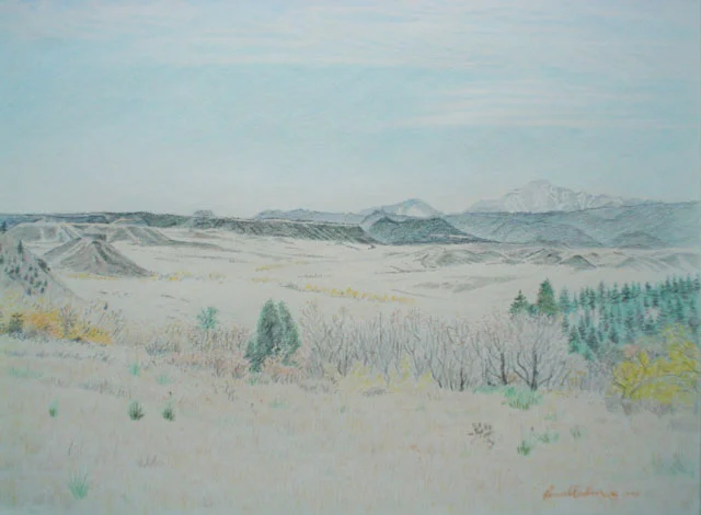
at the end of El Dorado Canyon south of Boulder
A summertime sketch of El Dorado Canyon where there is a ski resort along the Front Range between Golden and Boulder. This view gives a view of the end of the valley.
Drawn in colored pencil and graphite on 12 inch by 8 .75 inch white
Sale price is $50 unframed
Frame under glass

Mt. Antero after a Snow Fall
Mt Antero’s height of 14269 feet is accented even more with the glowing white of snow making it more grand and impressive. Living in Denver and having daily views of the Front Range and Pike’s Peak, Long’s Peak and Mt. Evans at 14000 feet and more is a treat to see their height increased and their attractiveness enhanced by winter’s white blanket. When the opportunity to see a peak or mountain up close covered in snow and up close is stunning. The view is from a road traveling from Buena Vista to the place shown where the road makes a wide descending curve to the left then around down to the Chalk Creek below as Mt. Antero looms directly above.
Drawn in colored pencil and graphite on 18 inch by 10 inch white
Sale price is $175 unframed
Frame under glass

Mt. Yale viewed from the Road up to Cottonwood Pass
It is early spring and the aspen have just started their bright green leaves in the cool days of early spring. Mt. Yale is in view with its pyramid shape elevating from the base below. Mt. Yale has a height of 14196 feet. one less than Mt. Princeton to the southeast. The view of Mt. Yale is to the north and the dark green of the nearby slope on the right is the western edge of Mt. Princeton.
Drawn in colored pencil on 14 inch by 10.5 inch on white
Sale price is $100 unframed
Frame under glass

La Plata Peak above Lake Creek
It is summer as the classic looking La Plata Peak still has a bit of snow in the highest reaches. There is a large expanse of conifer forest that descends down its northern side as shown reaching its lowest point along Lake Creek which flows from the Swatch Range and Independence Pass, an access to Aspen only available in the summer, to Twin Lakes Reservoirs south of Leadville area. La Plata Peak has an elevation of 14336 feet making it still nearly 97 feet shy of its larger and higher mountain neighbor to the north Mt Elbert at 14433 feet. This is is the backbone of the Rockies where there is a string of 14000 plus feet peaks from Tabaguache and Mt. Shavano to the south overlooking the Arkansas and Salida up to Mt. Massive north of Mt. Elbert and west of Leadville.
Drawn in colored pencil and graphite on 17 inch by 12 inch white
Sale price is $250 unframed Frame under glass

Castle Peak just south of Ashcroft and Aspen
It is an out of sight jewel where most visit Maroon Bells, Pyramid Peak, Snowmass, and Capital which are to the west of Aspen but Castle Peak is totally distinct with the rugged ridge coming off like a wing of teeth like jutting spikes going straight up which this feature makes it like a castle wall with its formidable formation. Castle Peak’s conical snow capped peak sets it apart from the features that descend from that peak. The time of year is early June so there is an abundance of snow even on the lower slopes.
Drawn in colored pencil and graphite on 18 inch by 12 inch white
Sale price is $300 unframed
Frame under glass

Mt. Columbia viewed from Buena Vista
Mt. Columbia looks like it rises above a flat surface called Berrian Park to its south and the Collegiate Peaks Wilderness at its base. Mt. Columbia rises to 14073 feet and it is a remarkable feature to the north of Buena Vista with its 5 fingers carved out of the trees by past avalanches.
Drawn in color pencil and graphite on 14 inch by 10.5 inch white
Sale price of $100 unframed
Frame under glass